File:Ordnance Survey Drawings - Sutton Coldfield (OSD 257).jpg
Jump to navigation
Jump to search

Size of this preview: 800 × 533 pixels. Other resolutions: 320 × 213 pixels | 640 × 427 pixels | 1,024 × 682 pixels | 1,280 × 853 pixels | 2,560 × 1,706 pixels | 4,000 × 2,666 pixels.
Original file (4,000 × 2,666 pixels, file size: 3.52 MB, MIME type: image/jpeg)
Captions
Captions
Add a one-line explanation of what this file represents
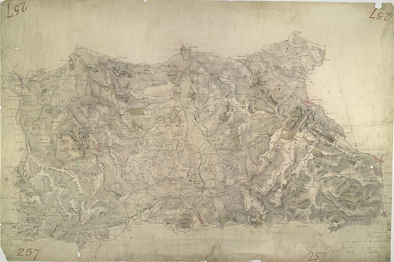
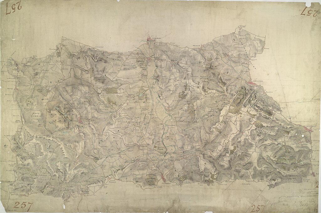
| Sutton Coldfield (OSD 257)
|
|||||
|---|---|---|---|---|---|
| Artist |
Dawson, Robert - Draughtsman |
.jpg) | |||
| Title |
Ordnance Survey Drawings: Sutton Coldfield, Birmingham (OSD 257) |
||||
| Object type |
manuscript map |
||||
| Description |
 Centre of map shown on a map of England
English: This drawing of the area north-east of Birmingham was executed by Robert Dawson, who used different shades of green to distinguish land uses. Sutton Coldfield is depicted at lower right, Aldridge at the top left. Tamworth is top middle; Coleshill lower middle. The River Tame flows north to Tamworth. Atherstone and Nuneaton are on the right-hand side. Hamstead, mispelled "Hampstead") is on the left. Now a residential suburb of Birmingham, Sutton Coldfield was originally a market town with Sutton Park. The 970-hectare site was a private estate and one of Henry VIII's favourite hunting grounds. Areas of woodland, heathland and wetland make up the landscape of the park..
This image has been georeferenced.
|
||||
| Language |
English |
||||
| Date | 1817 | ||||
| Medium | Pen and ink on paper | ||||
| Dimensions | height: 310 mm (12.20 in); width: 450 mm (17.71 in) | ||||
| Collection | |||||
| Accession number |
Maps OSD 257 |
||||
| Credit line | British Library | ||||
| Notes |
Scale 2 inches : 1 mile (1:31680). Please note that the British Library provides these digital files "as-is"; materials will not be rephotographed under this programme. If resupply of files is required, the requestor will be required to purchase them at the standard rate. |
||||
| References |
http://www.bl.uk/onlinegallery/onlineex/ordsurvdraw/s/002osd000000024u00217000.html (English) |
||||
| Source/Photographer |
|
||||
| Permission (Reusing this file) |
|
||||


.svg)
.jpg¶ms=52.567607_N_-1.694101_E_)
.jpg¶ms=52.442659_N_-1.970192_E_)
.jpg¶ms=52.692554_N_-1.418011_E_)
.jpg¶ms=52.692554_N_-1.918023_E_)
.jpg¶ms=52.48881_N_-1.970192_E_)
.jpg¶ms=52.442659_N_-1.470179_E_)
.jpg¶ms=52.646403_N_-1.418011_E_)
File history
Click on a date/time to view the file as it appeared at that time.
| Date/Time | Thumbnail | Dimensions | User | Comment | |
|---|---|---|---|---|---|
| current | 10:38, 26 September 2013 | | 4,000 × 2,666 (3.52 MB) | LibraryBot (talk | contribs) | {{subst:User:Andrew Gray/OSD|ID= 002OSD000000024U00217000 |OSD_NUM= OSD 257 |MEDIUM= Pen and ink on paper |TITLE= Sutton Coldfield, Birmingham |CREATOR= Dawson, Robert - Draughtsman |YEAR= 1817 |DESCRIPTION= This drawing of the area north-east of Birmi... |
You cannot overwrite this file.
File usage on Commons
The following 2 pages use this file:
.jpg&redirect=no)
File usage on other wikis
The following other wikis use this file:
- Usage on www.wikidata.org
.jpg&oldid=713428342)