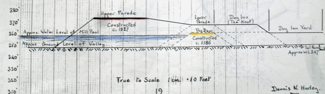
No-one knows how long ago it was that the causeway across the valley, now known as the Parade, was first constructed. Perhaps it started life as an embanked trackway, or perhaps it doubled up from the start as the dam for the town’s mill pool. One historian, the late Norman Evans, believed that the material used to build the causeway was quarried from the hillside where the Baptist Church car park is now, while Dennis Hurley calculated that the dam was a thousand feet long and ten feet high at its highest point.
In the Middle Ages the tenant of the Town Mill, which stood below Lower Parade, was responsible for the maintenance of the causeway-dam. It was strengthened and improved over the centuries, even being faced with stone early in the fifteenth century on the orders of the Lord of the Manor of Sutton, Richard Beauchamp Earl of Warwick. The causeway continued to carry the road across the valley after the pool was drained in the eighteenth century, and then in 1807 it became the responsibility of the newly-formed Birmingham and Watford Gap Turnpike Trust.
There had been an informal roads trust in Sutton since 1792, but with insufficient power to rectify the worst nuisance - Mill Street. Helen Holbeche recalled “I do not remember from what place the coach called the “Red Rover” came or went, but it passed through Sutton Coldfield in the morning after breakfast and people used to go and see it on its perilous journey down the dreadfully steep hill out of the Town. One morning when they were watching a cry arose “Good God it’s over” - it was quite true, it swayed and swayed and eventually toppled over.”
A Turnpike Trust could only be set up by Act of Parliament, but it was worth the trouble of obtaining an Act because of the powers it gave the trustees. The 1807 Act included a clause specifying what property on either side of Mill Street would be required for road improvements - for example “Pigsty belonging to Thomas Norris rented from the Warden and Society” - showing that a survey of the required improvements had already been made. However, it was not until 1824 that the work of halving the gradient of Mill Street was carried out.
A new embankment 200 yards long, estimated by Dennis Hurley to be 25 feet high at its highest point, was made across part of the former mill pool, requiring more material to build it than could be obtained by reducing the level of Mill Street at the top of the hill, described by Sarah Holbeche as “The top of the Town was carried to the bottom”. A considerable amount must have been quarried from the side of Mill Street where the car park is now, and the rest no doubt from the far side of Trinity Hill where the former school buildings now stand.
The completed scheme presented a bleak exposed appearance, so the trustees planted a row of lime trees with a view to shading and sheltering the traffic along the road, and their roots would stabilize the side of the embankment. Some of these lime trees are still there, giving welcome shade to Parade shoppers on hot sunny days.